Climate variability
The main objectives of this working group are:
- the development and sustainability of the ReOBS tool, which facilitates the use of long-term time series of observations performed at the supersites, in particular at SIRTA, for climate studies (Chiriaco et al., 2018)
- the elaboration of climatologies and the study of climate extremes
- a better understanding of the role of clouds and land surface/atmosphere interactions on the local climate variability and its evolution. Urban/climate activities start to develop.
- the improvement of methods/diagnostics of comparison between models and observations (e.g using lidar simulators, or deep learning)
- the use of all of this expertise to better evaluate and understand model biases
- favorize links with other WG (e.g WG4/WG5 for urban studies, WG3 for clouds properties) or other disciplines (e.g hydrology)
Laboratories involved: IPSL, LATMOS, LMD, METIS, GEOPS
Activities and projects:
- ReOBS: a new step in the development and sustainability of ReOBS has been proposed, in order to make ReOBS a tool easily transposable to other supersites or other datasets. ReOBS will become a service of AERIS and will be applied to datasets of ACTRIS-FR supersites and some supersites in Europe.
- Process analysis: Analysis of the observed role of clouds in the local temperature variability (see highlight#2). Link with ACTRIS-FR. Urban processes: caracterization of the mixing Layer Depth variability over and around Paris (see highlight#1). Link with others GTs and “Urban environments” thematics (including several financial support: GreenDeal, ANR …
- Model evaluation:
- Analysis of the triggering of precipitation in different multi-models ensemble, including convective-permitting simulations and comparison with observations. The relationship between tropospheric temperature, integrated water vapor and precipitation is analysed. Link with EURO-CORDEX (FPS convection), and EUCP projects.
- MOSAI french ANR project: Development of a new methodology based on machine learning statistical approach to better evaluate the surface fluxes in climate models. Link with ACTRIS-FR, DEPHY.
- Role of urban areas on precipitation: to what extent do convective-permitting climate simulations detect it over Paris? Link with CORDEX FPS convection, FPS URB-RCC and EUCP. Collaboration between LATMOS and METIS (hydrology).
Highlights:
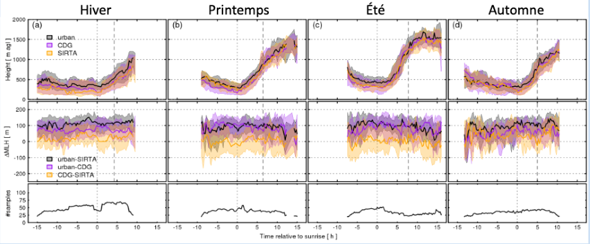
1. Caracterization of Mixing layer depth variability over and around Paris
Contact: Simone Kotthaus
The aim of the project is to detect and understand the impact of the urban area of Paris on the boundary layer structure, because of the importance of this layer on pollutants dispersion and cloud processes. This specific analysis here is based on the exploitation of the network of Automatic Lidar and ceilometer (ALC) which provide data over Paris center and suburban areas around Paris since several years.
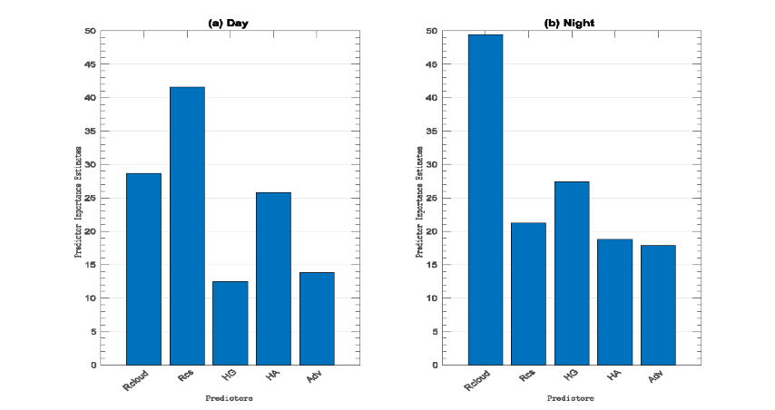
2. How clouds contribute to the local temperature variation in a context of global warming?
Contact: Marjolaine Chiriaco
This work is based on the analysis of SIRTA-ReOBS dataset, and a comparison with the Meteopole (Toulouse) dataset. A random forest analysis is performed to estimate which term is preponderant on the temperature variation.